Geography 2.0: Virtual Globes

AAG2007 Virtual Globes Logo

Tuesday, February 21, 2006

NASA World Wind for Pocket PC

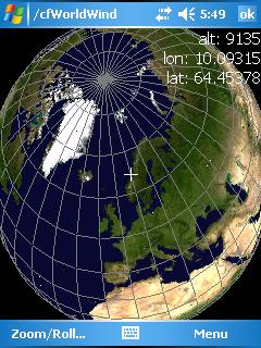
Recently, a UCSB graduate student said she dreamed of having Google Earth or NASA World Wind work on her PDA. "You know", I said, "I think I remember that from an old blog entry--for World Wind". I did a quick search and found it. From his May 13, 2005, blog entry (updated January 10, 2006), Casey Chestnut traces his experiments toward a Compact Framework version of NASA World Wind. The entry includes the resulting, successful source code. The commentary also links to a February 2005 .NET Rocks! podcast featuring NASA World Wind developers Chris Maxwell and Randy Kim.

screenshot by Casey Chestnut
Chestnut modified the NASA World Wind code as an experiment with portable device coding. In a November 28, 2005, post, he lists and rebuts several reasons Microsoft has disallowed similar experimentation with Xbox 360. According to Chestnut's post, Microsoft claims Xbox 360 is "not designed for it..", it would interfere with "console stability", and it does not directly support "DirectX". Chestnut's website resume states that he was recently hired by Microsoft. Maybe from the inside, he'll overcome the official obstacles, and I'll finally have an excuse to buy an Xbox 360.

Monday, February 20, 2006

3D Display with NASA World Wind

Fraunhofer-Gesellschaft, a German research institute, will be presenting a new 3D display at the CeBIT tradeshow, March 9-15, 2006, Hannover, Germany. The engineering team states that the monitor is "specially designed for use as a travel aid", and their test software has been a slightly-modified version of NASA World Wind. To maintain a stereographic view, a camera tracks the user's eye position and adapts the image to the visual angle. A somewhat similar holographic display was used for security at the 2006 Superbowl; see my 2Feb06 post for details.

If you want a "more" 3D virtual globe on your existing computer, an anaglyph plug-in has been created for NASA World Wind. It can be found at worldwindcentral.

New Virtual Globe?
According to the Fraunhofer website, "[institute] researchers are thinking about developing their own program on the lines of NASA World Wind or Google Earth".

ArcGIS Explorer FAQ

ESRI posted a FAQ about ArcGIS Explorer. It provides information on system requirements, data types supported, and customization details. For instance, the FAQ states that the software will be less than 20MB and work with Windows 2000/XP. Also, the following local data types can be used within ArcGIS Explorer: ESRI Shapefiles, File Geodatabases, JPEG 2000, GeoTIFF, IMG, KML, and KMZ.

AAG2006 Virtual Globes Schedule

Geography 2.0: Internet-based Virtual Globes
papers, panel, and discussion to be held in conjunction with the 2006 Annual Meeting of the Association of American Geographers

Thursday, March 9, 2006
Crystal Room, Palmer House Hilton, Chicago, USA

PRESENTATIONS
Sponsored by the AAG GIS Specialty Group
3:00pm-3:20pm, David Maguire - ESRI. Geographic Earth Explorers: A new software paradigm for visualizing and analyzing geography?

3:20pm-3:40pm, David J. Cowen and Kevin Remington -South Carolina. Integrating Google Earth and GIS: Exciting Opportunities

3:40pm-4:00pm, Mark Graham and Matthew Zook -Kentucky. The Soft-Ware and Hard-Where of DigiPlace: The Hybrid Spaces of Google Earth

4:00pm-4:20pm, Tim McGrath - Microsoft. Microsoft MapPoint: The Power of Location

4:20pm-4:40pm, Ming-Hsiang (Ming) Tsou - SDSU. Discussant

BREAK
4:40pm-5:00pm, Break

PANEL
5:00pm-6:40pm, Panel moderated by David Cowen.
Panelists: David Maguire (ESRI), Matt Nolan (EarthSLOT), Tim McGrath (Microsoft), Tom Gaskins (NASA).

RECEPTION
Sponsored by ESRI
6:45pm-7:45pm, An opportunity to chat with the panelists and meet others interested in virtual globes technology.

DEMONSTRATIONS AND DISCUSSION*
7:45pm-8:30pm, Tom Gaskins, NASA World Wind technical demonstration

8:30pm-9:15pm, Matt Nolan, EarthSLOT demonstration and globes education discussion.


* Not on AAG's web or print schedule. We will have pizza for those who are hungry.

If you have questions, feel free to contact the AAG2006 Virtual Globes organizers, Alan Glennon (glennon(at)umail(dot)ucsb(dot)edu) or Josh Bader (bader(at)geog(dot)ucsb(dot)edu).

For AAG2006 meeting and registration information, visit: www.aag.org/annualmeeting

Friday, February 17, 2006

Exploring Mars and measuring craters

Another graduate student--Karl Grossner--and I were staring at a Mars panorama, and it made me recall Keyhole NV Mars. I did a websearch, and it's hard to find much mention of it anymore. You can read Keyhole/Google's announcement of it going offline here.

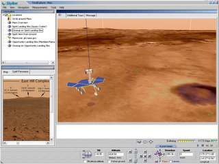
For those wishing to explore Mars, you still can do it with Skyline TerraExplorer. A free Mars virtual globe can be found on their main website. Look for the Mars Rover Mission thumbnail on the left side of the page; when you click it, further instructions for loading their globes browser will appear. Since TerraExplorer possesses several measuring tools, including distance, slope, vertical distance, and area, I had fun measuring the area and depths of craters near the Spirit landing site.


Windows-based NASA World Wind lets you explore Mars too, but it requires a plug-in. Actually, two Mars plug-in versions exist: a low-resolution (18MB) and a high-resolution (3GB). I've only installed the low-resolution version, but it was simple. It self-installed, and when NASA World Wind started, the option for Mars existed under the main File menu. The high-resolution version requires a little more installation expertise--including the need to load about 3GB of imagery onto your computer. The good news is that once it's loaded, you do not need an internet connection to explore Mars with fairly high-resolution imagery. For details on these plug-ins for NASA World Wind, visit the World Wind Wiki.

Several non-georeferenced Quicktime VR Mars panoramas can be found at www.panoramas.dk.

Wednesday, February 15, 2006

Skyline Online

While reading Declan Butler's articles in the weekly version of Nature, I did notice the following new-to-me information:

Skyline Software Systems, based in Chantilly, Virginia, was one of the first companies to offer a virtual globe: TerraExplorer. Later this year it will release Skyline Online, a browser-based tool similar to ArcGis Explorer. "It will empower users at home as well as researchers with capabilities that have been available only to government agencies until now," says company president, Ronnie Yaron.


For those unfamiliar with ArcGIS Explorer, it is ESRI's upcoming virtual globe designed to offer more out-of-the-box analytical functions than Google Earth. So, expect an analytically-enabled, internet-based virtual globe from Skyline later this year.

Nature weekly: "Mapping for the Masses"

The weekly version of Nature has several articles about virtual globes in its 15 February 2006 edition. The cover shot is of Google Earth with the byline, "Mapping for the Masses". The articles, most authored by Declan Butler, discuss how virtual globes are being used by scientists in various disciplines, how they work, translating the technology into tools for mapping the universe, and using the technology for mapping disaster areas.

Several of the articles are viewable for free online. Also, Butler is interviewed about the articles for the week's Nature podcast.

I would recommend visiting Declan Butler's blog. There's likely to be a great deal of discussion on related matters on his site.

Though I haven't completed a detailed reading of the articles, I know that Dr. Mike Goodchild from here at UCSB was interviewed. Happily, I was consulted too, but mostly just to clarify items discussed by Dr. Goodchild. Virtual globes mentioned: Google Earth, NASA World Wind, ArcGIS Explorer, Skyline Terra, and Celestia.

Tuesday, February 14, 2006

Maya to Google Earth

Overall, I try not to post items that are easily found elsewhere, but Stefan Geen's Ogle Earth posting about an exporter from Maya to Google Earth is worth repeating. The exporter was created by Eyebeam. Visit Ogle Earth or Eyebeam for additional details, screenshots, and commentary. As mentioned in my February 10th post, Maya software is now a property of Autodesk.

Sunday, February 12, 2006

Microsoft map mashups workshop

On March 1, the Massuchusetts Microsoft developer community is holding a half-day workshop, "Virtual Earth Madness", on building mashups for their online mapping technology. According to Thom Robbins, it's happening in Boston and also online.

I guess it should be called "Live Local Madness"--but that sounds like a call for chaos.

Details on the virtual event can be found on the Microsoft website (time: Wednesday, March 01, 2006 9:00 AM - Wednesday, March 01, 2006 12:00 PM (GMT-05:00) Eastern Time (US & Canada), welcome time: 8:30 AM, language: English). The session will be occurring at Microsoft's Waltham, MA, offices. Information on attending in person can be found on this MS Events page.

Friday, February 10, 2006

Virtual globes at the movies

We have lots of entertainment industry people in town this week for the Santa Barbara International Film Festival, so films are on my mind. One item brought to my attention was the January acquisition of Alias by Autodesk. Alias' Maya software, which is particularly useful for modeling particles, collision deformations, fluids, hair, cloth, and other realistic textures, is used widely in the film industry. Let's get that technology into virtual globes. By the way, one of the founders of Alias-Wavefront, Mark Sylvester, runs the Film Festival's blog and podcast.

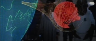
Though I haven't heard of any movies using recent virtual globes technology yet, I'm sure it's just a matter of time. Just for fun, I started thinking of virtual globes in film. Two classic examples are in Star Trek and Star Wars. In 1982's Wrath of Kahn, the Star Trek crew views a computer animation of terraforming (see: video/mp4). The sequence is one of the earliest uses of CGI in film, and the first to use fractal-generated landscapes. In Star Wars, we see a holographic Death Star in 1983's Return of the Jedi. According to this site, ILM designer Joe Johnston's virtual Death Star was the only computer-generated graphic in that film. I'll note that the Death Star hologram has the characters interactively working with it--albeit somewhat passively by just zooming on areas of interest. From wikipedia's timeline of early CGI, four of the first six instances of film CGI were used for maps. Groundbreaking computer-generated-imagery film effects seem to have started with maps and virtual globes.


Death Star hologram. source/copyright: www.starwars.com, 2006


Just as a final comment from festival conversations, I saw that Sketchup was used in the film production of "Good Night and Good Luck". In fact, Sketchup has a Film and Stage industry website.


Jeff Bridges and Alan Glennon at the film festival (photo by Rhonda Glennon, 4 Feb 06)


Post a comment if you have a favorite film virtual globe.

Digital Earth - San Francisco, June 2007

In my January 28th post on Edushi, I made a passing mention of a digital earth conference being held June 2007 in San Francisco. I received several inquiries about it, so I thought I'd post the website--the 5th International Symposium on Digital Earth.

Thursday, February 09, 2006

NASA World Wind expected updates

Everyone else has read the NASA World Wind blog and knows this already. However, if you haven't, in a January 18th posting, Chris Maxwell, one of the World Wind developers, says that they are committed to releasing their next update (v.1.3.4) in mid-to-late-February. Among the updates, they plan functionality for refreshable xml data. In the same post, he says v1.5 will be a huge leap forward and can be expected in late spring or summer.

Tom Gaskins of the NASA World Wind team will be at the March 9 AAG panel on virtual globes. We're arranging a time that evening for technical demonstrations by NASA World Wind and EarthSLOT. It's one month away! The AAG site only has a partial listing of the virtual globes goings-on, so I'll post a complete schedule within days.

Mapping non-spherical worlds

I was speaking to Don Janelle at the Center for Spatially Integrated Social Science (CSISS) yesterday, and we began talking about mapping non-spherical worlds. It turns out that one of his colleagues--Philip J. Stooke---at the University of Western Ontario has done a great deal of work on the topic. Stooke's website, though most of the pages stem from 1999-2000, covers a number of related topics--particularly relevant for virtual globes enthusiasts now that software tools increasingly allow for coordinate system customization.

Stooke gives a link to a poster (760K jpg) that offers a brief explanation of the Cartographic Options for Non-Spherical Worlds.

One page has maps and the numerical models of numerous asteroids and moons, as well as, a map of the nucleus of Comet Halley.

Stooke's latest book on the subject is expected soon.

Tuesday, February 07, 2006

a little less SimCity

USA Today mentioned that the Washington, DC, government had created a SimCity-looking webmap of the Mall. It's interesting, but only 1% of what's over at Edushi. (see my Jan 28 post for more on Edushi)

Also, Karl Grossner at UCSB sent me a note about Leica Geosystems. They have a demo online for their Leica Virtual Explorer. I downloaded the client, but could not get their demo data to run. The client default loads as a globe, but other options are available. Anybody seen this thing in action?

globes releases

I just noticed that Celestia moved from 1.3.2 to 1.4.0. The release occurred late December 2005 (changelog). The software is available for Linux, MacOSX, and Windows.

Four days ago Lunar Software updated their Earthbrowser software to version 2.9. Here's a few of the improvements they list: "fixed problem with near real time satellite overlays", "significant speed improvements", "Universal Binary for Intel Macs", and "new and improved database engine". Earthbrowser runs on MacOS X 10.1 and Windows XP/2K.

Saturday, February 04, 2006

More Satellite Tracking

In reference to my earlier post on satellite tracking, Sean Benison, a graduate student at NCGIA, showed me NASA's web satellite tracking tools. Several data delivery and visualization options are available. Their J-Track-3D display tracks satellites in real time with up to a 0.25 second refresh rate.

I've attached a screenshot. As a thumbnail, the satellites are not visible, so click the image to get a full screenshot.

A few more ArcGIS Explorer screenshots

I noticed that ESRI added a few more ArcGIS Explorer screenshots to their site. The images, one of the Washington Monument, one of the moon Europa, and one of the moon Ganymede, reflect a newer iteration of the software. So, ESRI is showing their software's ability to customize the coordinate system--in this case, with various iterations of a planetographic coordinate system.

The navigational controls have been simplified, and additional "Tasks" are visible. By the way, I was told that the "Swipe" tool that I mentioned in an earlier post is an old ESRI function. The tool allows layer transparency to be controlled interactively.

Friday, February 03, 2006

Tracking Spy Satellites

The February 2006 Wired has a fascinating article about amateurs tracking spy satellites. On its last page, the article provides tips on do-it-yourself tracking, and references an orbital inventory website Heavens Above. I need to look through their data and see if it's possible to get a glimpse of IKONOS or Quickbird.

Thursday, February 02, 2006

Holographic display

Intrepid Defense and Security Systems of Birmingham, Michigan, has developed a display that shows volumetric 3D images in free space. The display produces something akin to a full-color hologram without requiring users to wear glasses. Unfortunately, their webpage does not include any photographs or video of the unit in use. The rack-mountable rectangular unit looks somewhat similar to a medium-sized television. Screen size is ~50 cm (20 inches) diagonal.

I came across their press release while searching for information on Sunday's Superbowl. The display will be used for security during the game.

The company enumerates several spatially-centric potential applications for the product, including, "revealing details of ground images from satellites..", "lifelike flight-training simulation..", "making education exciting..", "space exploration..", and "underwater surveillance, threat assessment, exploration and recovery."

Wednesday, February 01, 2006

What do you call the technology behind Google Earth?

In the January 2006 Geoworld magazine, I found two items that may be of interest to virtual globe enthusiasts and scientists: an article comparing functionality of several virtual globes and a commentary on the challenges posed by internet mapping to traditional GIS.

The comparisons article focuses on providing short descriptions of Google Earth, Skyline Terra Suite, GeoFusion GeoPlayer, NASA World Wind, GeoTango Globeview (recently acquired by Microsoft), and ESRI ArcGIS Explorer.

Written by Matt Ball, the article refers to virtual globes as geographic exploration systems. The term apparently stems from definitions penned by ESRI's David Maguire for Geoworld Industry Outlook. Google defines their product as "a globe that sits inside your PC". Chris Laurel, creator of Celestia, defines his software as, "a real-time 3D space simulation". Personally, I am increasingly classifying the technology simply as virtual reality (VR); VR is an environment simulated by a computer. Still, I find myself using modifiers to VR like "geographic" or "geospatial". My non-geography friends tend to refer to the software by its product name, as a "computer globe" or, as "3D mapping software". If there are any awkward pauses during the March 9th AAG2006 Virtual Globes session or panel, I will pose the naming issue to our speakers and panelists.

In a provocative commentary on challenges to traditional GIS posed by internet mapping, Jeremy Crampton of Georgia State University, asserts:

Google could buy ESRI (if Jack Dangermond wanted to sell) and consider it a good week's work. However, it doesn't need to, because the map hacking industry is ahead of GIS now.

Regardless of my personal opinions of Dr. Crampton's statement, these are the types of discussions GIS and internet mapping professionals are having. Compared to five years ago, dinner conversations among geographers are much more lively.

ESRI's answer to Google Earth

According to this post at scrappad, ESRI's virtual globe--ArcGIS Explorer--is now in closed beta. Since the beta users are not allowed to talk about it, I thought I would. After all, much of the functionality of the product is revealed in the numerous screenshots shown at ESRI's ArcGIS Explorer Gallery. Just to be clear, I have not previewed this product other than seeing Bernie Szukalski's demonstration at the 2005 ESRI User Conference and screenshots on the ESRI webpage.

Business Model

First, let's talk money. While I am still unclear about the ultimate business model for Google Earth, ArcGIS Explorer is much more straightforward. Their website describes the product as a,

..geospatial information viewer that offers a free, fast, fun, and easy-to-use way to view geographic information—in both 2D and 3D—while performing queries and analysis on the underlying data.

Simple enough: A free, online geobrowser will drive the sales of ESRI's other commercial GIS offerings. This may be an oversimplification, but that can be examined in later posts. ESRI's David Maguire discusses the general philosophy behind ArcGIS Explorer in a December 22, 2005, blog entry.

Functionality

A quick look at their screenshots show a standalone MS Windows XP-style application with 80% of the screen area devoted to map display. The far left-hand portion of the screen is populated with various small tool windows. You can grab the windows, unpark them from the left menu area, and reposition them on other portions of the display.

From viewing the screenshots, tools include:

  • An intricate navigation interface somewhat similar to Google Earth. The controls also have several other search and target buttons; the window has an X button, so these menus can apparently can be closed and hidden.

  • Image and Inquiry "Tool" Menus. Presumably, the "Image" tool allows image/grid overlays. An Image popup box shows a vertical exaggeration slider bar, but no obvious transparency slider. Nevertheless, I would suspect a transparency slider is probably hidden somewhere in the product. I remember Bernie Szukalski previewing ArcGIS Explorer at the last ESRI User Conference; the vertical exaggeration occurred fluidly as he moved the slider. Though not particularly useful per se, it got an "ooh" from the crowd. The "Inquiry" tool likely allows attribute queries.

  • A "Task" list. Options under this menu include finding addresses, places, telephone locations, driving directions, etc. It seems like many of these queries could be integrated into a single menu item. However, a few intriguing and somewhat unique abilities may justify the multiple menus. For instance, the directions query includes options to return distances in preferred distance units, and also, route options like "fastest" (and probably "shortest distance"). Similar to Microsoft Live Local's "Locate Me", the "Task" list also includes a "Where's this Computer?" tool. Next, there's a tool to "Add KML or KMZ". The associated dialog box asks for the path or internet location of the KML/KMZ. It makes me wonder if ArcGIS has an analog to Google's Network Link KML functionality. Lastly, there's a menu dropdown for "Internet Search".

  • A "Results" window appears to provide a listing of query output.

  • A "Map Content" window includes the submenus "Add Data" and "Contents". There appears to be many server-based options to add data. I look forward to seeing whether they address dynamic data and representation refreshes. The "Contents" menu appears to pulldown as a table of contents of data on the map. In "Contents", mysterious tags are labelled "in range" and "out of range". We'll have to wait to see what that's all about; let's cross our fingers that it involves rendering only viewable data (to decrease processing overhead). Controls for cartographic customization were not readily apparent in the screenshots. Let's hope they cartography tools will included in ArcGIS Explorer's user interface. Currently in Google Earth, cartographic customization must be manually coded within KML.

  • Their gallery webpage mentions something called a "Swipe Tool". Its exact nature is unclear, but it apparently provides a user-friendly method to visually compare images of the same place photographed at different times.


Miscellaneous

Most existing virtual globes experience significant slowdowns with all but the smallest 3D datasets. I am eager to test the speed of this new ESRI product with our growing UCSB campus buildings model. Since ArcGIS Explorer will not automatically include a set of high-resolution satellite imagery, maybe we'll get some speed improvements for user-created data. Last, if this product allows accurate spatial analyses on a sphere (or better yet, the globe as an oblate spheroid), this release will be a major technological innovation.

According to the ESRI website, the public beta of ArcGIS Explorer is due in the second quarter of 2006.