
Microsoft Photosynth
All the standard sources have covered Microsoft Photosynth, but I wanted to mention a few additional links. For those who have not heard about it, Photosynth is a Microsoft Live Labs product that takes a collection of photographs, finds similarities, and arranges them in three-dimensional space.
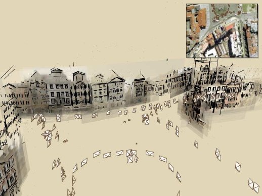
As Stefan Geens at Ogle Earth points out, the technology "certainly looks like a prime candidate for inclusion in Microsoft's upcoming 3D virtual globe." Frank Taylor's Google Earth Blog has a long entry with similar comments. For an overview, the Microsoft Photosynth site has a four minute promotional video. However, to really get a feel for what Microsoft is doing, it is worth watching the 38-minute-long Channel 9 interview with Photosynth Architect Blaise Aguera y Arcas. Microsoft Research has a website on the technology with a number of compelling screenshots.

Image: Microsoft Corporation, 2006

Image: Microsoft Corporation, 2006
For an interactive preview of the concepts, the University of Washington also has a webpage on Photo Tourism technologies. The site includes links to two videos, an ACM paper on 3D photo arrangement, contact information for the team members, and a live demo. To run the demo, make sure you have the latest version of the Java Runtime Environment installed. For Mac users, if the demo does not launch, the site recommends viewing in the Camino browser.
The question, of course, is when will these technologies be ready for mass consumption? Though unsubstantiated, I have heard rumors that it takes a prohibitively long time for images to be organized and aligned. All of these previews are impressive and promise great utility for virtual globes and modeling the world. I am particularly taken by the idea of image tags propagating through the net, allowing an image of an unknown location to be identified.
As Stefan Geens at Ogle Earth points out, the technology "certainly looks like a prime candidate for inclusion in Microsoft's upcoming 3D virtual globe." Frank Taylor's Google Earth Blog has a long entry with similar comments. For an overview, the Microsoft Photosynth site has a four minute promotional video. However, to really get a feel for what Microsoft is doing, it is worth watching the 38-minute-long Channel 9 interview with Photosynth Architect Blaise Aguera y Arcas. Microsoft Research has a website on the technology with a number of compelling screenshots.
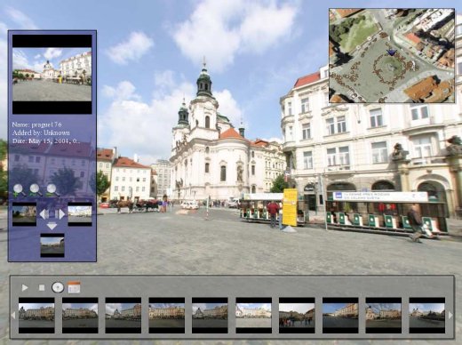
For an interactive preview of the concepts, the University of Washington also has a webpage on Photo Tourism technologies. The site includes links to two videos, an ACM paper on 3D photo arrangement, contact information for the team members, and a live demo. To run the demo, make sure you have the latest version of the Java Runtime Environment installed. For Mac users, if the demo does not launch, the site recommends viewing in the Camino browser.
The question, of course, is when will these technologies be ready for mass consumption? Though unsubstantiated, I have heard rumors that it takes a prohibitively long time for images to be organized and aligned. All of these previews are impressive and promise great utility for virtual globes and modeling the world. I am particularly taken by the idea of image tags propagating through the net, allowing an image of an unknown location to be identified.
posted by Alan Glennon at
9:18 PM
![]()
