
Conferences: ESRI and Sci Foo
While mostly I've been hunkered down coding, the brief pauses have been outstanding -- particularly the ESRI User Conference and Nature's Sci Foo.
ESRI User Conference
Other geobloggers have talked about the ESRI User Conference, but I'll add my two cents from a virtual globes perspective. First, I should disclose that I was only at the conference for two days, and did not attend any of the ArcGIS Explorer sessions. Mostly, I had conversations in hallways and chatted with exhibitors. Here's a few virtual globes-related tidbits:
Nature/O'Reilly/Google Sci Foo
Immediately after the ESRI UC, I flew to San Jose, California, to attend Sci Foo, hosted by Nature, O'Reilly, and Google. With the invited participants, I knew the gathering would be outstanding. I attended talks on data visualization, data sharing (by the guys at Maya), the semantic web, virtual environments (Second Life), INSTEDD and early detection (Larry Brilliant), NASA World Wind, peer review, dynamic updating on the web, teaching the scientific process to students, and reforming patent law. Sci Foo presentations and discussions were self-organizing, and in the end, there were too many interesting things to talk about and not enough time. I heard many positive comments about the sessions I missed; for instance, people were buzzing about a demonstration of a three-dimensional video camera. Fortunately, there's a Google Video on the topic.
On Sunday morning, Ogle Earth's Stefan Geens led a geobrowsers session, and the discussion got lively enough that we ran out of time. In fact, Stefan didn't even get to finish his talk. He did however post his examples online. I'll post my talk as a Impress/Powerpoint file in the near future. Called "Big Maps! powers of ten, map of the cat, and digital earth," it's about design issues associated with integrating spatial analysis functionality at all scales.
[update: corrected a misspelling]
ESRI User Conference
Other geobloggers have talked about the ESRI User Conference, but I'll add my two cents from a virtual globes perspective. First, I should disclose that I was only at the conference for two days, and did not attend any of the ArcGIS Explorer sessions. Mostly, I had conversations in hallways and chatted with exhibitors. Here's a few virtual globes-related tidbits:
- The Sketchup guys were there, and they answered a few of my questions about Collada. Their online materials show examples of what Collada files look like and how a kmz can call one. Also, I probably knew this, but had forgotten: educators are eligible for free Google Sketchup licenses (link).
- As I rounded the corner to enter my wife's talk on map design, I ran into John Hanke and some of the Google Earth team. I thanked them for sponsoring the geoblogger meetup. Of course, it's possible to buy a Google Earth t-shirt, but it just wears so much better when the Google Earth guys give one to you as a gift.
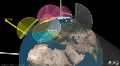
- If you are into virtual globes and don't know about AGI STK, you should. I learned about their software several months ago, and enjoyed the opportunity to meet with one of the their engineers at the exhibit hall. AGI often serves as my muse when contemplating virtual globes: the software allows objects to interact with time, and the AGI add-on modules offer fairly sophisticated three-dimensional spatial analysis tools (ie. volumetric intersections, dynamic fields, video/terrain matching, etc). Visit their website, download their viewer, and check out their demos.

Nature/O'Reilly/Google Sci Foo
Immediately after the ESRI UC, I flew to San Jose, California, to attend Sci Foo, hosted by Nature, O'Reilly, and Google. With the invited participants, I knew the gathering would be outstanding. I attended talks on data visualization, data sharing (by the guys at Maya), the semantic web, virtual environments (Second Life), INSTEDD and early detection (Larry Brilliant), NASA World Wind, peer review, dynamic updating on the web, teaching the scientific process to students, and reforming patent law. Sci Foo presentations and discussions were self-organizing, and in the end, there were too many interesting things to talk about and not enough time. I heard many positive comments about the sessions I missed; for instance, people were buzzing about a demonstration of a three-dimensional video camera. Fortunately, there's a Google Video on the topic.
On Sunday morning, Ogle Earth's Stefan Geens led a geobrowsers session, and the discussion got lively enough that we ran out of time. In fact, Stefan didn't even get to finish his talk. He did however post his examples online. I'll post my talk as a Impress/Powerpoint file in the near future. Called "Big Maps! powers of ten, map of the cat, and digital earth," it's about design issues associated with integrating spatial analysis functionality at all scales.
[update: corrected a misspelling]
posted by Alan Glennon at
2:35 PM
![]()
