
Imagery updates for Google Earth
Google Earth blog reports several imagery upgrades for Google Earth. The official word is that most of the updates are for Germany. As someone with an affinity for geysers, I have noticed improvements, though arguably minor, for Kamchatka (Russia), Chile, Iceland, and New Zealand--the location of the world's largest geyser fields outside of Yellowstone. These basemap 15-meter resolution areas are now covered by TruEarth imagery.
Here's two files to highlight the imagery upgrades (mostly for my geyser science friends):
Here's two files to highlight the imagery upgrades (mostly for my geyser science friends):
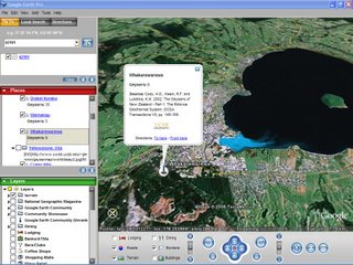
- My KML of the world's major geyser fields. If you visit Whakarewarewa Geyser Field, Rotorua, New Zealand, notice Sulphur Bay is now visible. It's the turquoise inlet at the southern portion of lake. Several redundant imagery glitches now exist, however, near Orakeikorako. Much of the cloud cover at Kamchatka and Iceland is now gone. The United States' second largest remaining geyser field--Geyser Bight, Umnak Island, Alaska--is now cloud free.
- My more-detailed KMZ of El Tatio Geysers, Chile-(info page). The area appears to have higher contrast in this newer imagery. There is less bleeding of the overexposed siliceous sinter regions onto adjoining pixels.

posted by Alan Glennon at
1:02 AM
![]()
