
KML in Google Maps: a little rough
Having KML work in Maps is a fine idea, so I thought I'd test it with my KMZ of Chilean geysers. To use the new KML/KMZ functionality for Google Maps, you just type in the URL of the KML or KMZ in the Google Maps Search box. For instance, my geysers database is at: http://www.alanglennon.com/geysermap/chile.kmz
When I try it, I get the following error message at the lower lefthand side of the screen: Parts of http://www.alanglennon.com/... could not be displayed because it is too large.
As such, from my KMZ, only about 50% of the basic data are imported. Much of the window formatting, folders, and image overlays are either discarded or corrupted. I am sure the Google Team is working toward full compatibility.
A few screenshots:
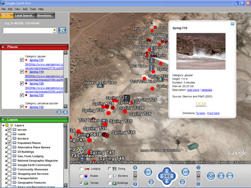
The KMZ in Google Earth. The 70-cm imagery of this isolated Chilean field is wonderful. As a side note, if you search the database and examine Geyser T87 (due to registration issues, look 20 meters west of T87), the new imagery shows it as a white blur. That is T87 erupting. Perhaps the new texture tools will allow me to take my catalog of eruption imagery and apply them to 3D geometry.

The KMZ in Google Maps. Though the imagery is still 15 meters/pixel, the Google team says they are working to make the imagery updates occur simultaneously in Earth and Maps. Icons and window formatting do not survive the Earth-to-Maps transition.
posted by Alan Glennon at
8:16 PM
![]()
